Book status report

Color: Over the last few months I have gotten into publishing color books…even with the color going right to the edges…bleeds. And my primary printer, Lightning Source, has come up with a lower-cost color option. So I definitely think the book will graduate to color pictures of the trips and construction. 

Trip: My around-the-island trip has yet to happen, and I have pretty much lost the services of my first mate, who mutinied after getting seasick the year before this. But that cloud has a silver lining since she can serve as my ground crew if something goes wrong or I need supplies. After all, Prince Edward Island is no more than a 4 hour drive from end to end and with her living on the island there is no water to cross…a trip to Newfoundland would be a different story, So my resolve is strengthening to do the trip next summer.

Grant: The Southern Kings Arts Council has advertised grants to support struggling artists and they consider writers as qualifying. The grants are up to $1200 if one qualifies, and so I have applied for the sailing book. The color option will increase the price and none of these publishing activities are great profit activities. While my current focus is on the Revisiting Scripturebook(s), a grant would be the incentive to get going on the sailing book as well.

autumn last leaves


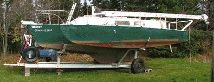
Projects:So as of now the boat sits in the side yard, waiting for the snow, with only minor work to do…the trailer modifications are about done and the radio replacement can happen in the spring. The last of the autumn leaves are still a brilliant yellow on the maple trees, but winter feels close.


Single-handing with autopilot

The last two trips out on my 26′ trimaran I have gone alone. Partly that is due to no one being available and partly due to my primary ‘crew’ resigning…she has decided she doesn’t like wind and big waves and she got seasick. It turns out that the key is an autopilot…in this case a ‘Tiller Pilot’. With it in place I can go forward or below without fear that the tiller will shift to one side or that, even holding in one place, the boat will gradually turn in the wind. Not that a machine can replace a person…especially my wife…but it frees me up to do adjustments without the panic of having to do everything in 30 seconds. There is nothing like the quiet relaxation of sailing along in moderate winds and seas with the autopilot managing the details. The only time I take over is when going diagonally in following seas running with the wind…constant change is needed to head down the waves and then head sideways in the troughs.

I’m making up a checklist of things I should do before starting out single-handed from my home port of Wood Islands. It amazes me how many things there are to do when they are listed out…no wonder I have managed to forget some.:

  1. Print out a tide schedule so I can estimate the current amount and direction… will it be significant when coming out at Wood Islands? Falling current is east by up to 3 knots while rising is west up to the same speed. Look up the marine forecast online…not that that is particularly trustworthy…to see if there are any warnings…winds are usually less that forecast or later in arriving…perhaps due to the length of Northumberland Strait. If a trip to a destination is planned then the wind direction matters.
  2. Drive to an overlook and check how high the waves are…should I abort the trip?
  3. Arriving at the boat, unlock the companionway boards and put them in a locker. Make sure the water level in the bilge is not above the upper threshold for the pump (be sure it is working). Glance around to see if anything is obviously wrong.
  4. Read the wind gauge and evaluate the shape of the various nearby flags for wind indications. Based on those bits of data as well as the marine forecast, choose which sails and reefs to set.
  5. Tie the boat close in to the wharf ladder and remove the normal bow, stern, and spring lines.
  6. Lift the fenders (old tires) and leave them on the wharf.
  7. Lower the outboard into the water and start it to be sure it is functional…and then stop it.
  8. Turn on the instruments…GPS, marine radio, and fish-finder.
  9. Retrieve the autopilot from its storage locker below and connect it to its power socket…be sure to turn on its power.
  10. Put on your life-jacket.
  11. Check the ferry schedule so you won’t be going out when it is going through the narrow outer passage…even though there is room to pass safely, it apparently worries (or ‘pisses off’) the captains.
  12. Remove the jib cover from the chosen front sail and remove the cover and unstrap the mainsail. Attach the sheets to the leech (?…the back lower corner) of the jib.
  13. Raise the jib and tie off its halyard (lifting rope); set the sheets so the jib is on the correct (downwind) side for the wind direction going out of the harbor. 
  14. Raise the mainsail…then unhook the boom from its hold-up wire. Tie off the mainsail halyard and keep that sail sheeted at the center…not off to either side yet.
  15. Loosen the rope tying the boat to the wharf ladder and start the outboard. As the boat begins to move, cast off and keep the tiller almost straight ahead so you don’t rub the wharf.
  16. Keep a lookout for unexpected traffic and motor out to open water.
  17. Choose a direction, set the autopilot on auto, adjust the sheets for the wind direction, stop the motor, and begin the joy of sailing!

Compleat Cruiser

I am almost done reading  The Compleat Cruiser: The Art, Practice and Enjoyment of Boating by L. Francis Herreshoff (first printed in 1956). It has been one of the most enjoyable books on short-distance (non-blue-water) cruising I have encountered because it is told as a story. The reader casually is introduced to Mr. Goddard and his young-teen daughter, Miss Prim (for Primrose) who are taking short sailing trips around  the North Shore above Boston, MA.  While there are details slipped in about boat designs (the author’s skill and fame), the account paints a picture of the enjoyment of the journey. The moments of concern due to occasional squalls or shallow water fade as we are go along experiencing the cooking of meals and sitting on the boat in the quiet of the evening or engaging in informal ‘races’ with fellow sailors who happen to be going the same direction. The evenings often entail sitting around with these other boaters discussing everything under the sun…with a focus on sailing. More than any other book I’ve read, this one brings out the fun of simple short-run cruising.

I have often read books promoting the benefits of simplicity in cruising…no motor…no special electronics…no water heater or pressure…etc. Herreshoff makes some of those same arguments relative to initial cost of boats, maintenance costs, insurance costs, and so on. If he were still living and still making the same arguments, however, I would take him to task over a few items which were either prohibitively costly or totally unavailable back then.

  1. I think every boat above 20′ ought to have a depth sounder/fish finder. These can be had for about $100 and make running aground much less likely…especially if you are single-handing and couldn’t use a line.
  2. Navigation without a GPS in this day is foolish…especially if you might get out of sight of land. I recently changed my hand unit (~$200) for a low-end chart-plotter which cost about $450. Half of its value is the inclusion of charts which otherwise cost about $20 each.
  3. LED running lights and cabin lights are far superior to the old incandescent ones and the oil lamps in the cabin (I ;know some argue the atmosphere is better inside with oil). Add a solar charger (say 15 watts) and a deep-cycle battery and you have all the   power for your lights unless you run all night every night.

To be sure, power boaters define ‘necessities’ differently, but I consider the above items to be essential and affordable for those with small cruising sailboats. 

Now in the water!

Today the boat finally got launched. This year’s problems were relatively minor…one tire continued a slow leak after being re-seated and had to be removed a second time…the wind-vane (brand new) broke off when the mast top swung over the wharf before I had the boat tied up. Oh, one of the mast step rungs snapped off as I was climbing up to remove the mast-raising hook. But on the positive side, the boat floated free the first time and the mast raising went without a hitch. The early-morning rain stopped and the day was sunny. The wind was out of the northwest, which didn’t interfere with the launch or the mast raising. 

Still, even with my wife’s help, I am exhausted. There are so many memories of things that went wrong I continue to wonder what will be next. Perhaps by Sunday I will have the halyards up and the sails attached and actually be able to go sailing!

They’re gone!!!

The young starlings…fledglings…have left the nest within the last two days. Finally I can launch the boat without doing harm to young birds. It also happens that the high-high tides are falling this time of month (6.9′) from 9:30 tomorrow (Wednesday) through 12:00 noon on Saturday. I think we’ll target Friday…11:15 is the high and that means the boat can be trailered to the ramp sometime in the morning…at a time to miss the ferry traffic…with plenty of time to extend the tongue and get the boat floated while the high tide lingers long enough to allow the trailer to stay safely up from the drop-off at the bottom end of the ramp.

The entire process takes several hours between extending the tongue, floating the boat, resetting the tongue, motoring the boat over to the wharf, raising the mast, and bringing the trailer home. Actually I intend to bring the trailer to Graham, my handy machinist/welder, to fix the width as well as adding a cradle/roller to align and capture the bow when bringing the boat onto the trailer again. Being about 15′ wide, I don’t like to have it on the road any more than possible, but it is no worse than much of the farm machinery one encounters here. I will try to be careful to pick times when ferry traffic is not racing along toward or from Charlottetown.

Probably I’ll have 8 weeks for sailing, barring any ill-aimed hurricanes.

Books and Sailing Dreams

The Dream

Reading can be dangerous! The more I read of nautical achievements (and most mariners seem to write books to pay their way around the world), the more I wanted to try it myself. Usually such cruising involves going between continents—off to Europe from the east coast or across to Hawaii from the west coast, for example. Even beyond that are the round-the-world circumnavigations and the single-handed trips that are the subject of many books. I recommend Tinkerbelle, an account of a single-handed trip to England from Massachusetts in a 13’ sailboat, or Slocum’s classic, Sailing Alone Around the World. I recently encountered a blog on the web posted by a 16-year-old girl sailing single-handed around the world from Australia in a 26’ pink sailboat.

I could imagine sailing around PEI or on down to the south shoreof Nova Scotia. Why not sail on down to visit my brother near Plymouth, Massachusetts? It should not be difficult to sail to Newfoundland or even up the coast of Labrador. After that, why not go on down to Bermuda or the Bahamas? It brings me to mind of Bilbo Baggins in Lord of the Rings,

The Road goes ever on and on
Down from the door where it began.
Now far ahead the Road has gone,
And I must follow, if I can,
Pursuing it with eager feet,
Until it joins some larger way
Where many paths and errands meet.
And whither then? I cannot say.[1]

My “door” is the WoodIslands harbour, about two miles from our house. Just think! With the right preparations, I could sail to any coast in the world from there. With a sailboat, the fuel costs would be minimal. About then I began to see the need to divide my nautical travel and boat recommendation books into categories:

  • Tiny racing boats (tip them over and right them by yourself)
  • Daysailing (out and back to the same place within a few hours)
  • Weekending (short trip with one or two overnights)
  • Coastal cruising (for perhaps a week or two)
  • Bluewater cruising (far away from land)
  • Circumnavigation (around the world in a year or two)

When you dream, dream big! Then learn Wisdom and appreciate your limitations. Continue reading “Books and Sailing Dreams”

Sailing Around the Island

A (non-sailing) friend I was telling about my requirement of sailing abound Prince Edward Island before finishing my sailing book recently said, “That can’t be hard. How long should it take…2 days?”

The reality is that it is about 475 km or 300 miles around. If I were to sail day and night It could perhaps be done

  1. if I had night sailing skills
  2. if I had at least two others to share the watches
  3. if I didn’t care to stop and see any of the shore
  4. if (and here’s the big IF) the winds cooperated.

In comfortable winds the trimaran makes 6 knots with no difficulty and has been up to 9 or 10 knots, but the stronger winds are accompanied by rough seas especially in Northumberland Strait where the side shores serve as a wave guide. 6 knots would involve about 45 hours of sailing as long as the winds held and conveniently reversed as the boat rounded the island—that would be the 2 days. Of course, if one used a speedboat with lots of spare gasoline, found a really calm day, and pushed at 20 miles per hour or faster, the trip might be done in one day, but that defeats the purpose. Continue reading “Sailing Around the Island”

Winter Dreaming

Well, it is not technically winter here in Atlantic Canada, but it isn’t really spring either!

I spent some early morning hours today dreaming with my yet-to-be-installed GPS chart-plotter (Lowrance Elite 5m). The GPS part is nice, but the chart function is great too. With charts costing $20 each (and they still require someone to plot the coordinates before you can find out where you are), the $450 for the unit was a bargain. One hand-held GPS easily costs $150 and if I had to buy 15 charts I would come out even. Now I  have charts for all of North America and even rough outlines for the rest of the world. I couldn’t find out the harbours of Tasmania but I could at least head for land. Add a simple world atlas and  basic navigation would be possible. Admittedly I have to click the no-liability statement at start up, so the fact that my electronic charts are easily 15 years behind (the Confederation bridge connecting PEI to the mainland is not there and that is hard to miss) is not a big problem…assume most shores have not moved significantly. and come into harbours carefully using the depth sounder.

Back to the dream. It is fun to move the pointer around the Island and imagine sailing into the various harbours. Which ones would be sheltered from strong NW winds and waves? Which ones would most likely have access to supplies? See how the most tempting direct path to the wharf would take me over shallow water…would my 3 foot draft get me in trouble? How far could I go in a day? Are there enough intermediate harbours in case the wind changes? As I say, it is fun to plan a hypothetical trip. I still have the around-the-island goal and requirement before I will release my book, and the GPS is a significant part of that.

Its too cold for Epoxy to set, so I might as well dream.